|
Seasonal
Outlook: Winter 2023/2024 (Released: October
25, 2023) As
I always start out, I am sure that most of you are familiar with my feelings on
seasonal weather forecasting, but for those of you that have not done so
already, you might want to check out my "Soap Box
Speech on Seasonal Weather Forecasting". The bottom line is, no one
should be making any serious decisions, such as buying/not buying a sled or gear
based on this or any outlook. OK, so with the usual disclaimer over, it is time to get
down to business. As many of you have heard, El Nino has reared its ugly head in
the central equatorial Pacific and has only been growing stronger since late
last winter/early spring (figure 1). Current forecasts call for a leveling out
of the sea surface temps through this winter and then cooling to commence next
spring, but a weak to moderate El Nino is likely to continue through most of
this winter. So, like the 2014-15 winter, El Nino will likely be the
gorilla in the room this winter, what does that mean? I think the two most
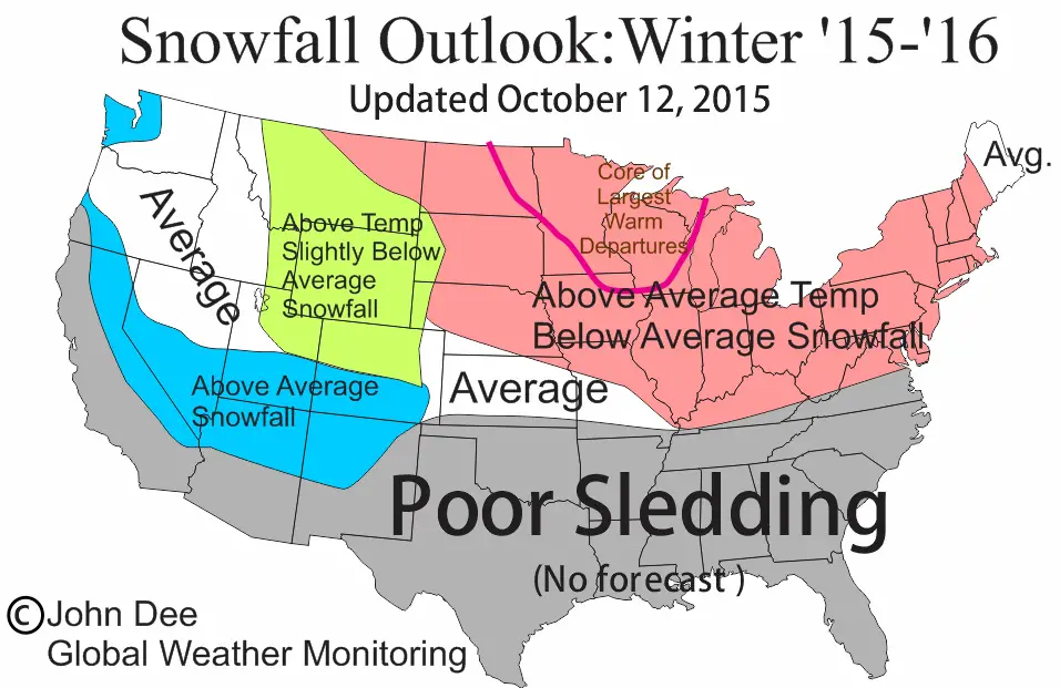
important things to recognize with El Nino are: I am going to let the graphic do most of the ugly
talking, but will add that while the news looks quite bleak for this winter
across most of the northern US, there will still be snows that fall and periods
of decent snow-play across the northern US this winter. There are some other factors that I use when making this
outlook. One of them kind of attaches itself to an El Nino. That is the
occurrence of any late-October/early November head fake snows that can
sometimes happen when an El Nino is happening. This head fake is a 1-3
week period of below average temps and even sometimes a significant snow event
for portions of the upper Midwest. This can lead to false expectations of a cold
and snowy pattern setting up for the winter. That has not happened so far and the forecast does not
hold any real chance of a major snow event to occur in the next week to ten
days. There does look to be some heavy snow that will fall in MT and ND later
this week and then into SD by the weekend, with just a coating possible in most
of MN, the northwest 1/3rd of WI and much of the UP by the middle of
next week. There are a few more tools that I like to use when
producing this outlook. I dont want to divulge what they are, but can say the
they are not providing much of a steering forecast for this winter. So without further ado, here is the
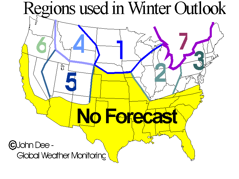
breakdown by region: REGION
1 The Northwest Midwest: The news is not good. El Nino typically causes temps
to be well above average and also snowfall to be a bit below average. There will
be snows that fall, I can guarantee that! The problems will be an increased
potential for periods of thaws and snow loss. So while this area will still
probably be one of the best bets for snowplay east of the Rockies, one will have
to watch the forecast closer and perhaps chase storms more than is usual. Lake
snows will likely be less than average as well, but will still provide the best
and freshest snow east of the Rockies. REGION
2 The Southeast Midwest: The news for this region is not good as well.
While temperature departures may not be as large for the season as they are in
the NW Midwest, the NW Midwest is a much cooler region on average. Thus, this
region will still see some snow storms, perhaps even a doozie, but struggle with
more frequent thaws and low snowcover. REGION
3 The Northeast US: This is always a tricky region when an El Nino is
happening. Typically the signals for above average temps and below average
snowfall are caused by an El Nino. However those signals are not as strong as
they are in the north central US. I can add that, there is actually an increased
chance for NorEasters to develop out of lows passing through the southern US
and bring crippling snows to areas from NY city north. REGION
4 The Northern Rockies: This region is typically impacted by El Ninos
in a negative way. Not so much with the temps, as most of the snow-play is done
in elevations that are immune to warm winters. However, the main storm track in
El Nino winters typically happens to the south and well to the north of this
region and thus the result is for less than average snowfall. So after a pretty
lack-luster winter last year, this one is looking to be only slightly better. REGION
5 The Central Rockies: As with the northern Rockies, I see the
northern ½ of this region to see less than average snowfall occur, but
departures will not likely be as large as to the north. Plus, the southern 1/3rd
of this region could end up with above average snowfall in the higher terrain,
as El Nino will tend to make the storm track across the southern Rockies more
active. REGION
6 The Pacific NW and Sierra Range: Most of this region will likely see
above average precipitation result in above average snowfall for the higher
terrain. Despite the odds of a record or near record seasonal snowfall for much
of the mountains in CA, I think this winter will be snowier than average. The
northern ½ of this region will likely see a busier than average storm track,
but the result will not seem or be as dramatic as that to the south. The further
north you go, the less positive influence El Nino will have on snow-play. REGION
7 Eastern Canada: The story for eastern Ontario, most of Quebec and
the Maritime Provinces is pretty similar to the Northeast US.
Meaning that I believe the winter will be a bit warmer than average, with
the snowfall to run a bit below average. Not by huge margins, plus the
opportunities for several large storms exists. Further
east, in areas of Ontario, the snows will likely be lighter than average and if
you get far enough east, there may even be some areas that end up being milder
than average for the winter. But
hey, its Canada eh? Its winter
eh? Break out the tuque and lets go Ski-Dooing!
|
||||||
|
|